APPLICATIONS
DOWN stream
Geolux is working closely with the University of Zagreb’s Faculty of Civil Engineering to carry out hydrological monitoring on the Neretva Delta.

The valley of the river Neretva is located at the south of the Croatian Adriatic coast, where the river mouth forms a delta. The surface area of the delta is 12,000ha, and the surface of the drainage basin is approximately 10,500km2. The total length of the Neretva River is around 225km. In the past, the Neretva delta consisted of 12 tributaries. More recently, the number of tributaries has been reduced to only four through numerous hydro-technical reclamation processes. By gradually draining out the swamp, the delta has been transformed into a fertile agricultural area that is abundant with great natural wealth and agriculture diversity. The Neretva valley has been used to serve a dual function: during high-water levels, it is used as a relief channel, and in the dry season, it is used as a reservoir of freshwater for irrigation. Between 1968 and 1972 two dams with floodgates and ship locks were built on Neretva: one upstream of the agricultural area in Opuzen, and the other at the delta. The dam in Opuzen controls the water inflow, while the other dam prevents the penetration of salty seawater into the Neretva. Salt intrusion represents a great threat to the whole Neretva ecosystem and can result in reduced crop yields. State and local authorities, the national water management company Hrvatske vode, and the academic community in Croatia are continuously working on improving flooding protection in the Neretva valley and its irrigation capacity, as well as preventing the intrusion of saltwater into the agricultural area. The University of Zagreb’s Faculty of Civil Engineering is performing continuous hydrological monitoring of water level and flow in irrigation channels in the Neretva river valley. The Faculty of Civil Engineering has procured Geolux instruments for continuous water level and flow monitoring at four selected locations on the delta. Geolux has provided the instruments and related equipment and has performed the equipment installation.
Non-contact radar
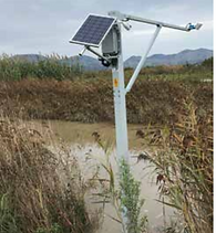
An important decision factor for the Faculty of Civil Engineering, when selecting Geolux instruments, was the fact that the instruments use non-contact radar technology for the measurement of both water level and water flow (discharge). The instruments are installed above the water surface and are not in contact with the water itself. This makes the installation of equipment easier, and the maintenance is minimal. Water flow is calculated using the index velocity method by measuring the water level and surface velocity. Non-contact radar instruments are commonly installed on an existing overhead structure, such as a bridge, over a water surface. As there are no such structures near locations chosen by the Faculty of Civil Engineering, Geolux had to propose a different solution for mounting the instruments above the water surface. Custom-designed aluminum poles with an extended arm were constructed and installed at the irrigation channel bank so that the arm that holds the radar instruments extends over the water. All four stations were installed in two days. During the first day, an excavation was made in the ground of the channel bank for a concrete base, and concrete was poured to form a foundation for mounting the aluminum pole. A few days later, after the concrete had been cured, the external formwork was removed, and the aluminum pole was attached to the foundation. The instruments – radar level meter and surface velocity radar – were attached at the end of the extended arm, while the enclosure with datalogger, solar panel and backup battery were attache
first day, an excavation was made in the ground of the channel bank for a concrete base, and concrete was poured to form a foundation for mounting the aluminum pole. A few days later, after the concrete had been cured, the external formwork was removed, and the aluminum pole was attached to the foundation. The instruments – radar level meter and surface velocity radar – were attached at the end of the extended arm, while the enclosure with datalogger, solar panel and backup battery were attached directly to the pole.
Gaining accurate measurements
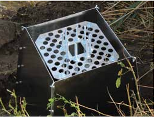
To provide accurate and reliable measurements, it was important to ensure that the wind does not cause noticeable vibrations of the mounting pole and extended arm. The concrete foundation, the aluminum pole and the arm were designed to withstand the maximum expected wind at the installation sites with minimal vibrations, to ensure measurements are not affected. In general, the accuracy of the radar level sensor is not greatly affected by the vibrations when the device is configured to use a longer averaging filter. The accuracy of the surface velocity radar can be decreased if the instrument vibrates while it makes the measurement. As a general rule, the arm with the surface velocity radar should not oscillate more than a few centimeters in each direction, with a period not shorter than half a second. Aquatic vegetation at the monitoring sites poses another obstacle to measurement accuracy. The vegetation grows at the channel banks and also protrudes from the water surface near the banks and grows up to 2m in height above the water. If the vegetation is within the range of the radar beam, it can affect the radar measurements of both the water level and surface velocity. Unlike most similar products on the market, the Geolux radar level sensor has a special operation mode where it can automatically detect the vegetation above the water and measure the true distance to the water. The surface velocity radar measurements are affected by the vegetation when the wind moves the vegetation back and forth. By configuring the surface velocity radar to use a longer averaging filter length, such problems can be minimized. To achieve the most accurate measurement results, it is recommended to configure the instruments accordingly and to properly maintain the monitoring site by regularly cutting down the vegetation. To ease site maintenance, Geolux has installed a camera at each site. The camera, Geolux HydroCam, takes periodic snapshots of the monitoring site and delivers the images together with the measurements to the central server. By looking at the recent site photos from the camera, it is obvious when the vegetation is too high and needs to be cut down.
Strong results
The four monitoring stations were installed in the Neretva river valley nine months ago. The analysis of the measured data indicates that there is no decrease in measurement accuracy caused by the pole vibrations. The design of the concrete foundation and the aluminum pole with an extended arm has been proved to firmly keep the instruments above the water surface. The aquatic vegetation on sites requires both proper configuration of the devices and periodic site maintenance. The planning of maintenance is made simple by the availability of near-real-time photos from each monitoring site. Geolux is dedicated to supporting its clients, from suggestions about site selection to instrument installation and configuration of operating parameters. This project from the Neretva river valley is an example of how Geolux has closely cooperated with its customer, from the planning stage and data analysis, to obtaining the best possible results.