APPLICATIONS
DISASTER prevention
Hydrological stations from Geolux will transform Croatia’s monitoring network, leading to improved early warnings that will save lives.
In 2014, devastating floods hit the town of Gunja, Croatia, resulting in the loss of life, homes and infrastructure. The floods were triggered by heavy rainfall and swollen rivers, causing two dams more than 25km apart to burst simultaneously. Croatia responded to the disaster by launching several initiatives aimed at preventing similar events in the future, including the VEPAR (Vodno Ekološko Praćenje, Analize i Rješenja) project, aimed at improvement of non-structural measures for flood risk management. With a budget of €33m (US$35m), VEPAR seeks to enhance Croatia’s capacity to monitor and predict floods, and improve early warning systems and response capabilities. The project is being carried out by Hrvatske vode, the Croatian legal entity for water management, and the Croatian meteorological and hydrological service DHMZ as a partner. It is co-financed by the EU from the European Regional Development Fund and is scheduled to run until August 2023. The VEPAR project is an ambitious undertaking aimed at modernizing and upgrading the hydrological network of monitoring stations to prevent catastrophic flood events in Croatia and beyond.
Project breakdown
Through 11 subprojects, VEPAR will provide and systematize missing data related to basins, watercourses, and regulatory and protective water structures; modernize and upgrade the hydrological network of monitoring stations; improve prognostic models; prepare and improve flood risk management studies; procure necessary equipment to implement flood protection measures; and educate and inform the public. One of the most significant undertakings of the VEPAR project is the modernization of more than 630 hydrological monitoring stations spread across the country. The upgrade includes the installation of radar-based sensors for accurate water level and flow measurements, additional cameras for real-time situational awareness, and advanced sensors for monitoring water temperature and quality. Geolux, a provider of hydrological monitoring solutions, is playing a crucial role in this subproject. As the primary supplier, Geolux is responsible for delivering its LX-80 radar level sensors, RSS-2-300WL radar flow meters, SmartObserver dataloggers, HydroCam cameras and HydroTemp water temperature sensors. The use of non-contact radar instruments lowers overall equipment installation and maintenance costs.
Geolux HydroStations
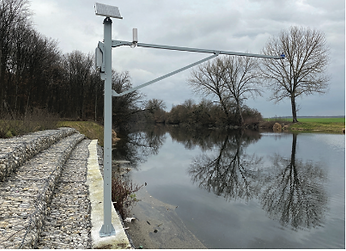
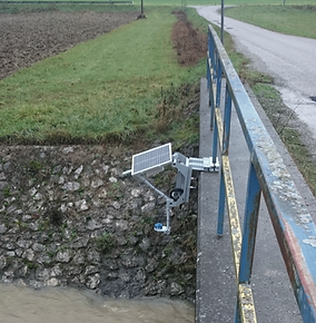
Geolux has developed an innovative solution to enable quick and easy installation of hydrological monitoring equipment on site. The company delivers the equipment preassembled in the HydroStation package, which includes a mounting assembly, waterproof and vandal-proof enclosure for the backup battery and datalogger, and mounting holders for the solar panel and radar instruments. The HydroStations are manufactured in Geolux’s factory and shipped as a set, simplifying installation and configuration in the field. With a typical installation and setup time of less than one hour, the HydroStations can be easily mounted on the side of a bridge or other suitable location. Furthermore, the versatility of the SmartObserver datalogger enables HydroStations to be subsequently expanded to incorporate additional hydrological or meteorological equipment, providing flexibility and adaptability for future needs. The monitoring stations have a two-level redundancy system to maintain real-time data availability in the event of equipment damage or network failure. At the first level, critical monitoring sites have two independent sets of equipment installed, each with its own power supply, datalogger and instruments. The primary set of equipment uses radar level sensors, while the backup set uses bubbler level sensors, thus ensuring continuous measurements even if one set of equipment is damaged. On the second level, critical sites use two different communication systems for real-time data transmission. The primary link uses cellular GSM/GPRS/4G communication, but during a disaster, when cellular
the first level, critical monitoring sites have two independent sets of equipment installed, each with its own power supply, datalogger and instruments. The primary set of equipment uses radar level sensors, while the backup set uses bubbler level sensors, thus ensuring continuous measurements even if one set of equipment is damaged. On the second level, critical sites use two different communication systems for real-time data transmission. The primary link uses cellular GSM/GPRS/4G communication, but during a disaster, when cellular networks are overloaded with people trying to contact emergency services and family members, the system switches to a secondary LoRaWAN datalink transmission system. This redundancy guarantees continuous water level and discharge data availability, even in the worst-case scenario.
Smart software
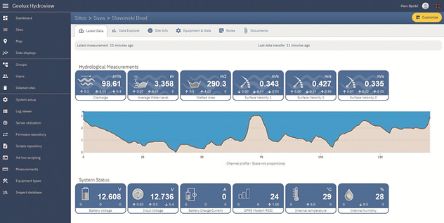
Geolux HydroView software is the central hub for collecting, visualizing and managing all measured data from the modernized monitoring stations. It offers various tools for simple remote management, equipment diagnostics and visualization and analysis of measured hydrological and meteorological data. Users can arrange monitoring sites in groups, customize dashboard views, and select the most relevant data for presentation. One of the standout features of HydroView is the configuration of dynamic measurement time intervals, which enables the monitoring site to switch automatically to a shorter measurement interval according to the water level or discharge volume. For example, when the water level rises above a specific threshold, a site that measures and transmits data every 15 minutes can automatically switch to five-minute measurements. Additionally, HydroView enables remote firmware updates and reconfiguration of any instrument parameters. With the HydroCam camera installed at the monitoring site, HydroView provides the ability to remotely perform visual inspection of the site by displaying the latest image and historical site images. Finally, HydroView has advanced capabilities to calculate discharge using a number of methods, including the rating curve method, Parshall flume, and discharge based on measurement of the water level and surface velocity. The VEPAR project is a testament to the dedication and collaboration required to address the growing threat of floods in Croatia. With Geolux’s expertise in hydrological monitoring equipment, the project is well equipped to achieve its goal of modernizing more than 630 monitoring stations across the country. The advanced technology used in this project, such as radar measurements of water level and flow, additional cameras for situational awareness, and monitoring of water temperature and water quality parameters, will provide invaluable data to help prevent catastrophic flood events. By the end of 2023 the VEPAR project will undoubtedly be among the most modern and technologically advanced integrated water resources monitoring systems in the world, setting a standard for other countries to follow. The success of this project highlights the importance of investing in advanced technologies to manage the growing risk of natural disasters and protect the safety and well-being of communities.