APPLICATIONS
HIGHER TECH
Non-contact methods for measuring river levels and discharge provide increased reliability, accuracy and cost efficiency.
Earlier this year, the Belgian Centre for Research on the Epidemiology of Disasters compiled a report analyzing 315 natural disasters from 2018, the effects of which impacted 68 million people globally. According to the report, floods affected more people than any other type of disaster in 2018, which was in keeping with findings from previous years (along with drought). A key component for the successful implementation of flood prevention mechanisms, as well as the real-time detection of rising water levels and flood emergency response management, is the availability of accurate, real-time, quantitative hydrological data. Planning of drought mitigation strategies, such as construction of dams and irrigation channels, also depends on reliable hydrological measurements. However, traditional hydrological monitoring stations can encounter several issues that negatively impact the accuracy and reliability of measured data. For example, submerged instruments require regular maintenance, while complex, expensive installations often result in fewer stations being deployed as part of a network (meaning the flow from tributaries is not monitored). Relying on a single communication link at remote locations can also result in the delayed delivery of data, thereby preventing the real-time detection of rising water levels. The vandalism of accessible instrumentation is also a concern. In its mission to reduce the harm caused by flooding and drought disasters, Geolux has developed a family of instruments that facilitate the accurate and reliable monitoring of water levels and discharge in rivers, channels and lakes, while overcoming some of the challenges faced by current instruments.
GEOLUX LX-80 SERIES
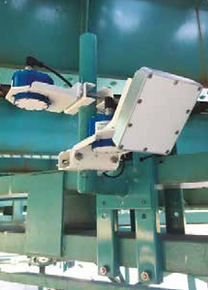
With its LX-80 water level sensors, Geolux leverages 80GHz radar technology with advanced software-defined radio (SDR) processing to measure the distance from the instrument to the water surface. As the instrument is installed above the water, the installation is simple and maintenance minimal. For discharge measurement, LX-80 is paired with the Geolux RSS-2-300W surface velocity radar, which also measures the surface velocity from above the water. Combining water level measurement and surface velocity measurement with the profile of the river channel results in an accurate discharge measurement. Several other methods exist to measure or calculate the total discharge of water in a river or channel. Direct measurement using an acoustic Doppler sensor is one such approach, but high unit costs and complex maintenance procedures can be problematic. For smaller streams it is possible to accurately calculate the discharge by measuring the water level at a weir or flume. On wider rivers, Q-h curves are traditionally used to determine the discharge based on the water level. However, due to the hysteresis effect that can be observed on Q-h curves, it is not possible to accurately determine the water discharge based solely on water level measurement. Additionally, in certain conditions the river flow direction can be reversed, such as in tidal rivers or when downstream tributary contribution forces the water flow to reverse direction. The measurement of the water level cannot show if the river flow direction has been reversed, and when discharge is calculated based on Q-h curves, the results are highly inaccurate. Therefore, the measurement of both water level and surface velocity of the water provides a simple method for the precise measurement of water discharge. The surface velocity correlates with the average velocity in the river channel, and the total discharge can be calculated by multiplying the area of the channel cross-section underwater with the average surface velocity. The area of the channel cross-section under the water can be determined from
level measurement. Additionally, in certain conditions the river flow direction can be reversed, such as in tidal rivers or when downstream tributary contribution forces the water flow to reverse direction. The measurement of the water level cannot show if the river flow direction has been reversed, and when discharge is calculated based on Q-h curves, the results are highly inaccurate. Therefore, the measurement of both water level and surface velocity of the water provides a simple method for the precise measurement of water discharge. The surface velocity correlates with the average velocity in the river channel, and the total discharge can be calculated by multiplying the area of the channel cross-section underwater with the average surface velocity. The area of the channel cross-section under the water can be determined from water level measurement, and the relationship between the measured surface velocity and average flow velocity can be determined either through numerical simulation or by performing on-site calibration measurement. For wider rivers, it is possible to install multiple surface velocity sensors across the channel, which results in increased accuracy of the calculated water discharge.
GEOLUX SMARTOBSERVER DATALOGGER
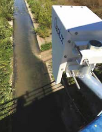
Both the radar level sensor and surface velocity radar support multiple communication interfaces that make integration with third-party dataloggers possible. However, for a tightly integrated turnkey solution, Geolux has developed a robust datalogger with integrated maximum power point tracking (MPPT) battery charger and modular wireless communication interface that supports protocols such as GPRS, 3G, NB-IoT and LoRaWAN. The Geolux SmartObserver datalogger was specifically designed to support power management of power supply lines for all connected instruments, resulting in extremely low power consumption. For example, a hydrological station without a solar panel and powered from a single 20Ah battery can make and send water level and discharge measurements every 15 minutes for at least three months. The ability to get a real-time picture of the measurement site allows visual inspection of conditions at the site remotely. Geolux HydroCam is an affordable, low-power camera that connects to the SmartObserver datalogger and periodically takes a photo of the measurement site and delivers it to HydroView cloud-based software.
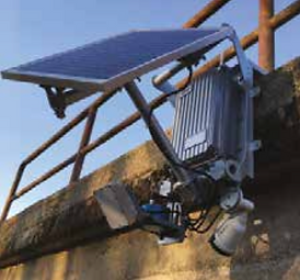
HYDROVIEW
Hydrological data is delivered in real time over a wireless network to a cloud-based software solution developed by Geolux. HydroView software enables the users to monitor hydrological data in real time, analyze and export historical data, reconfigure dataloggers and instruments remotely, and receive alerts and warnings. HydroView supports multiple discharge calculation models including Q-h curve based and V-notch weir based, and is based on measurement of water level and surface velocity measurements. For quick and simple installation, Geolux offers a highly integrated HydroStation package that consists of a premounted solar panel, a vandal-proof watertight aluminum enclosure holding a datalogger and a battery, and the radar level sensor, surface velocity radar and HydroCam inspection camera. All of the components are attached at the factory and delivered as single unit ready to install by the customer. Additional third-party instruments such as precipitation sensors, air temperature, humidity and pressure sensors, and anemometers can also be added to the HydroStation configuration. Installation of a Geolux HydroStation on an existing structure over the water surface (such as a bridge) typically takes 30 minutes. The compact design of the HydroStation helps protect all the instruments and equipment from vandalism.